
Working Groups
Web3D Consortium Working Groups are technical committees that consider and develop solutions for specific technical challenges and opportunities. Working group charters are reviewed by the Board of Directors to meet the needs of the Consortium and the community.
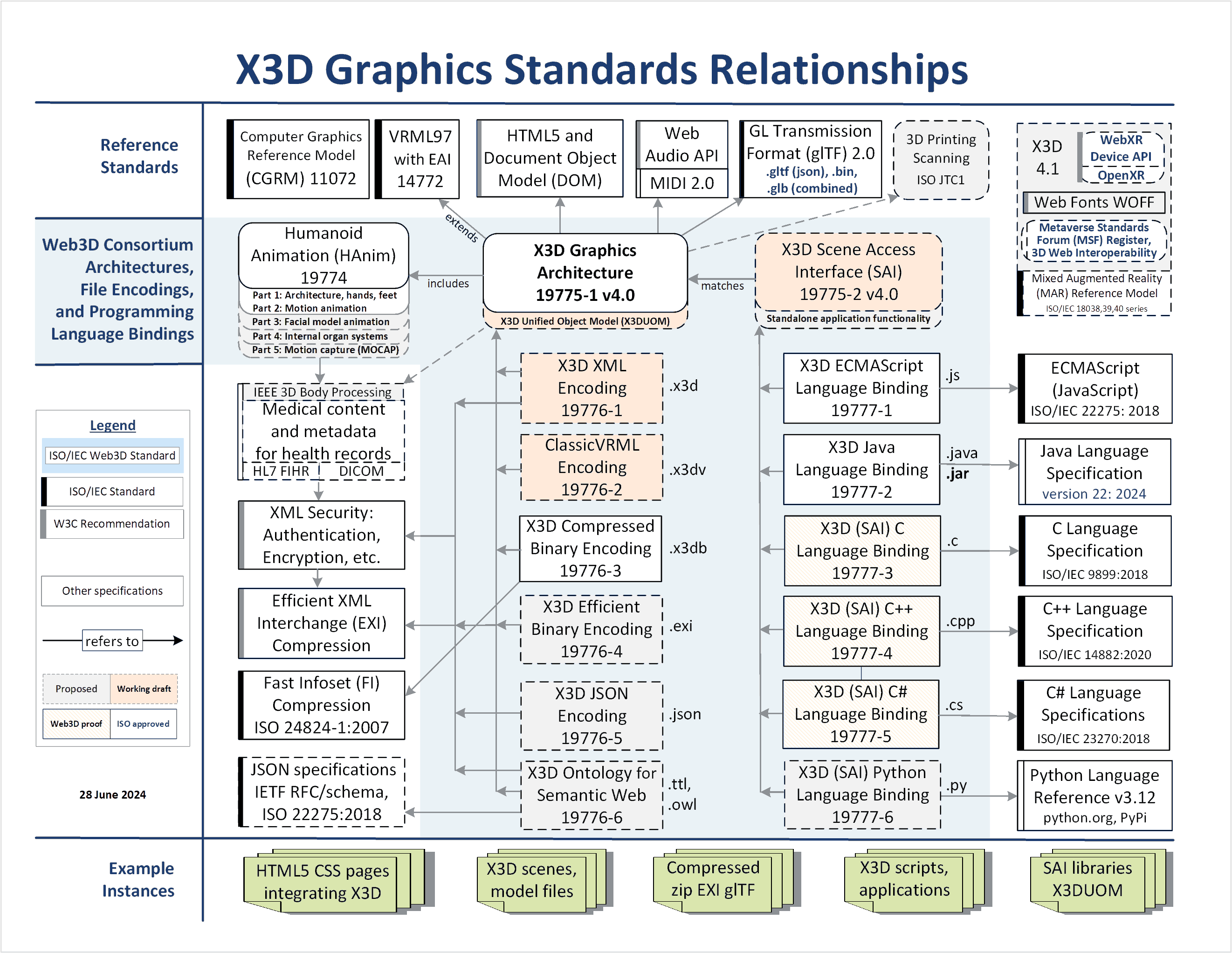
The Extensible 3D (X3D) Working Group coordinates all Web3D Consortium technical development efforts. Working groups are essentially driven by the efforts of participants. They focus on issues and technologies that produce improvements to our open standards, always achieving results that are royalty free for any purpose. All efforts are geared towards improving a coordinated set of steadily evolving ISO standards including X3D Version 4.
Members only mailing lists - Open to Web3D Consortium Members.
Working Groups
This preliminary charter serves as a discussion document for the Special interest Group on AI with X3D, outlining its purpose, objectives, and operational framework. The group is committed to advancing the intersection of AI and 3D graphics, fostering innovation, and promoting collaboration among its members and the broader community. If X3D models include metadata and common best practices that support AI training and 3D model generation, powerful new capabilities might arise.
The Cultural and Natural Heritage (heritage) Working Group is exploring the generation, handling, and display of digital 3D data for cultural and natural heritage.
The Design Printing and Scanning Working Group develops and demonstrates best practices for X3D support of Computer-Aided Design (CAD), 3D Printing, and 3D Scanning applications
The Geospatial Working Group works to make it easier to create and use 3D spatial data within X3D via open architectures.
The HAnim Working group develops and demonstrates the Humanoid Animation (HAnim) International Standard. HAnim supports a wide variety of articulated figures, including anatomically correct human models, incorporating haptic and kinematic interfaces in order to enable sharable skeletons, bodies and animations.
The Medical Working Group for X3D develops and demonstrates open interoperable standards for the representation of human anatomy based on a wide variety of imaging modalities.
A Special Interest Group - Mixed and Augmented Reality (MAR) capabilities present computer-generated information within the real world, developing compatible extensions to X3D visualization and interactivity that implement an emerging ISO reference model.
The Web3DUX working group develops and demonstrates best practices for X3D support of rich user experiences using a variety of Web3D technologies and content-delivery platforms.
The X3D Ecosystem Special Interest Group (SIG) brings together industry and 3D graphics expertise to improve the deployment X3D in real-time interactive 3D worlds.
The X3D Semantic Web Working Group mission is to publish models to the Web using X3D in order to best gain Web interoperability and enable intelligent 3D applications, feature-based 3D model querying, and reasoning over 3D scenes.